KONGSBERG DPS i2 is a sensor fusion GNSS solution designed specifically for dynamic positioning (DP)
Core positioning and design philosophy of the product
Product ownership: Belonging to the Kongsberg DPS i series, it is a sensor fusion GNSS solution that integrates decades of GNSS and inertial technology, designed specifically for ship dynamic positioning (DP) applications.
Design core: To create a fully scalable and future oriented positioning reference solution, emphasizing the operational efficiency of DP operations, ensuring DP performance without the need for third-party DGNSS enhancement services, and being compatible with various differential correction services as needed.
Technical core: Combining the latest multiple GNSS technologies with Kongsberg’s unique * * MGC ™ The deep integration of motion gyro compass (INS inertial technology) enables the complementary advantages of GNSS and INS, solving the positioning limitations of a single system.
Core technology integration and positioning principle
Satellite and inertial sensor fusion: DPS i2 adopts GPS, GLONASS multi frequency satellite positioning, combined with MGC ™ The motion gyro compass (also compatible with MRU 5+, MGC R3/R2) is a unique integrated design in the industry, which can achieve stable DP positioning performance without additional enhancement services, and can also use differential correction and SBAS services as needed.
Complementary positioning logic: GNSS solves the problem of long-distance positioning, while INS (Inertial Navigation) compensates for the positioning gap caused by GNSS signal obstruction, flicker, and interference, achieving continuous position calculation while improving positioning stability when GNSS signals are limited.
Integrity monitoring upgrade: On the basis of traditional RAIM (Receiver Autonomous Integrity Monitoring), INS data is integrated to form INS assisted RAIM, ensuring the ultimate reliability of position and velocity data in complex GNSS environments.
Core performance indicators
The positioning and speed accuracy of DPS i2 are based on actual operating conditions in Beihai, and the update frequency supports multi gear adjustment. The core performance parameters are as follows (accuracy is 95% CEP circular probability error):
Specific parameters of performance indicators
Non differential positioning accuracy 1.3 m
High precision positioning accuracy<10 cm
DGNSS positioning accuracy<1 m
SBAS positioning accuracy<1 m
Speed accuracy<0.01 m/s
Reference separate specification document for roll/pitch accuracy
Data update frequency 1-20/200 Hz
MGC/MRU data delay<1 ms
Core functional characteristics
The functional design of DPS i2 revolves around the safety, efficiency, and flexibility of DP operations, with features such as basic positioning, functional expansion, convenient operation, and service support
Enhanced positioning performance
Dual frequency ionospheric compensation: eliminating the influence of ionosphere on satellite signals and improving positioning accuracy;
High precision arm compensation: correcting arm errors in position and velocity data to adapt to physical deviations in ship installation;
Compatible with various calibration services: Supports RTCM-SC104 full version and Seastar series differential calibration to meet different accuracy requirements.
Function expansion capability
GNSS heading: Equipped with two DPS systems, GNSS heading calculation can be achieved;
Deception detection: Multi system fusion+scalable design, supporting GNSS signal deception detection, enhancing positioning security;
Data recording and playback: Automatically record positioning data, support playback function, facilitate job analysis and troubleshooting.
Sensor reuse and efficiency improvement
MGC ™ Reuse: The inertial sensor MGC can also serve as a WheelMark certified gyro compass and provide data for shipborne navigation equipment and attitude data demand systems, achieving multi-purpose functionality;
Zero operating costs: No need for routine maintenance, calibration, or additional consumables, significantly reducing operational investment.
Operation and Service Support
Customized HMI: an intuitive graphical human-machine interface jointly developed with senior DP operators, which can quickly and effectively evaluate the positioning quality in operations and adapt to safety critical DP operations;
Scalable design: The flexible hardware architecture can adapt to the DP requirements of any ship, and multiple sets of DPS+MGC/MRU combinations can achieve global high-precision heading calculation;
Remote Service: Supports K-IMS remote service, enabling remote job support and troubleshooting, replacing traditional on-site engineer on-site services.
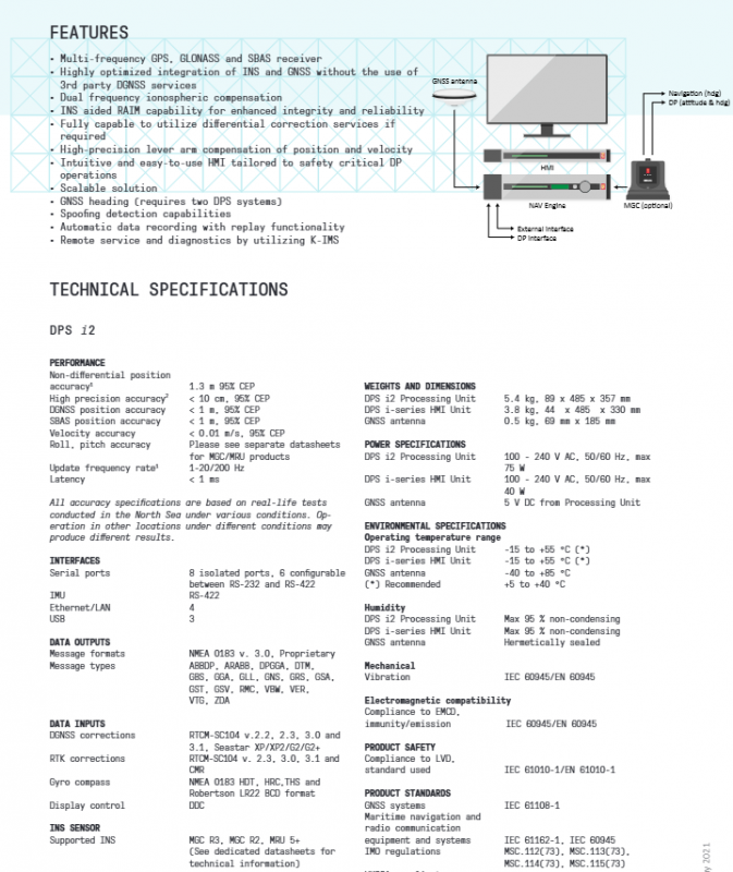
Hardware specifications and interface configuration
DPS i2 consists of three parts: processing unit, HMI unit, and GNSS antenna. The power supply is wide voltage AC, with rich interfaces and support for isolation design. The core hardware parameters are as follows:
Weight and size of hardware components (mm) Power supply standard Maximum power consumption
DPS i2 processing unit 5.4 kg 89 × 485 × 357 100-240 V AC 50/60 Hz 75 W
DPS i series HMI unit 3.8 kg 44 × 485 × 330 100-240 V AC 50/60 Hz 40 W
GNSS antenna 0.5 kg 69 × 185 5 V DC (powered by processing unit)-
Interface configuration: Equipped with 8 isolated serial ports (6 can be configured between RS-232/RS-422), 4 Ethernet/LAN ports, 3 USB ports, and 1 RS-422 (IMU inertial sensor), the interface is rich and anti-interference, suitable for the complex electrical environment of ships.
data interaction
Data output: Supports NMEA 0183 v.3.0, Kongsberg proprietary format, including more than 20 message types such as GGA, GLL, GSV, etc;
Data input: compatible with DGNSS calibration, RTK calibration, gyro compass data, display control data, and adaptable to various onboard equipment.
Environmental and Product Standards
The environmental specifications of DPS i2 are suitable for harsh working conditions in global maritime operations, and the product standards comply with mainstream certifications and regulations in the maritime industry. The core requirements are as follows:
Environmental specifications
Working temperature: Processing unit/HMI unit * * -15~+55 ℃ (recommended+5~+40 ℃), GNSS antenna -40~+85 ℃ * *;
Humidity: Processing unit/HMI unit with a maximum of 95% non condensing, GNSS antenna fully sealed design, suitable for high humidity and salt spray environments;
Mechanical characteristics: Compliant with IEC 60945/EN 60945 anti vibration standards, electromagnetic compatibility (EMCD) meets anti-interference/emission requirements.
Product Standards and Certification
Safety standards: comply with LVD, IEC 61010-1/EN 61010-1;
Maritime standards: comply with IEC 61108-1, IEC 61162-1, follow IMO regulations (MSC. 112 (73), etc.), UKOOA specifications;
Satellite system standards: compatible with the universal standards of GNSS global satellite navigation systems.